Shop


South Florida Marine Map
$549.00
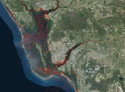
ISLA’s South Florida marine map is an easy-to-use map that provides the utmost accuracy and visibility for inshore navigation for South Florida (South of Sarasota and Sebastian). Unlike other nautical charts, it covers all of South Florida, not just specific counties or regions. The map includes landmark features, boating tracks, and high-resolution imagery that allows you to zoom in without pixelation. The map is the most accurate available, with regular updates to ensure it remains up to date. It is created by running each marine track individually, making sure they are accurate, safe, and reliable. With this map, you can explore areas you’ve only dreamed about, without worrying about damaging your hull. Read More…
Simrad:
- Simrad NSO Series (All Sizes)
- Simrad NSS EVO 2 (All Sizes)
- Simrad NSS EVO 3 (All Sizes)
- Simrad EVO 3s (All Sizes)
- Simrad GO Series (All Sizes and all Model Versions)
Lowrance:
- Lowrance HDS Series Gen 1, 2, and 3 (All Sizes)
- Lowrance FS 7 and FS 9
- Lowrance HDS Carbon (All Sizes)
- Lowrance LIVE (All Sizes)
- Lowrance Elite Ti 1 and Ti 2 (All Sizes)
B&G:
- B&G Zeus Series (All Sizes)
The waters around South Florida can be troublesome. But ISLA’s South Florida marine map makes it easy to navigate with confidence! The utmost in accuracy and visibility, our customers have named it “the best boating chip on the market.” This budget-friendly chip is the easiest to use for inshore navigation.
Unlike other nautical charts, all South Florida is available—not separate chips for each county or region. With ISLA’s South Florida reef map, the water is your backyard!
In addition to landmark features and boating tracks, we’ve also included high-resolution imagery that rivals anything you’ve ever seen. Feel free to zoom in with no pixelation!
What’s Included
All ISLA charts are comprised of images and a base map with features.
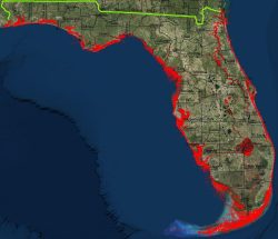
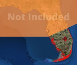
The South Florida base map includes features for the entire state but only high-resolution imagery for South Florida. The imagery includes all areas south of a line that runs from Sebastian Inlet to Sarasota Bay.
Track Coverage includes:
- Sarasota
- Fort Myers
- Naples
- Sebastian
- Loxahatchee
- Miami
- Biscayne Bay
- Lake Okeechobee
- Lower St. Johns River system
- St. Lucie River system
- The Everglades and 10,000 Islands
- The Florida Keys to the reef line
- Lakes Passage
- Marquesas Keys
- Tortugas National Park
- Coastline and intracoastal waterways
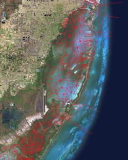
The Most Accurate South Florida Marine Map
There are plenty of other marine maps and GPS chartplotters to choose from. But we’ve heard the complaints from our customers that these maps are inaccurate, outdated, or just plain difficult to look at.
These charts often use government data that is outdated. In many cases, the data isn’t double-checked or corrected.
We believe you deserve better. That’s why we strive to make sure our South Florida marine map is the most accurate one available. We also provide updates to ensure your boating days remain carefree.
In addition to unparalleled accuracy, this South Florida marine map boats high-quality images, allowing you to see the most detail at the highest resolution. Zoom in to 50-feet with no blurring or pixelation!
How Did We Do It?
Our maps don’t rely on existing NOAA satellite imagery, as we’ve found it to be off by multiple feet. As any boater knows, it only takes a few inches of depth to take you from smooth sailing to running aground.
We ran each of these marine tracks ourselves, making sure that they are accurate, safe, and reliable. Our South Florida reef map will make it possible to explore areas you only dreamed about, with no worries about damaging your hull.
Florida boasts some of the best fishing and top-notch marine views in the country. It’s time to get out and explore with Florida Marine Tracks.
For questions regarding our products, please visit our FAQ page or contact us for further assistance.